Showing posts with label Longview. Show all posts

Thursday, November 07, 2024

Grayland State Park, Coastal Southwest Washington

 Grayland Beach State Park, Coastal Southwest Washington

We drove to Tokeland for gasoline.  Breakfast in Raymond.

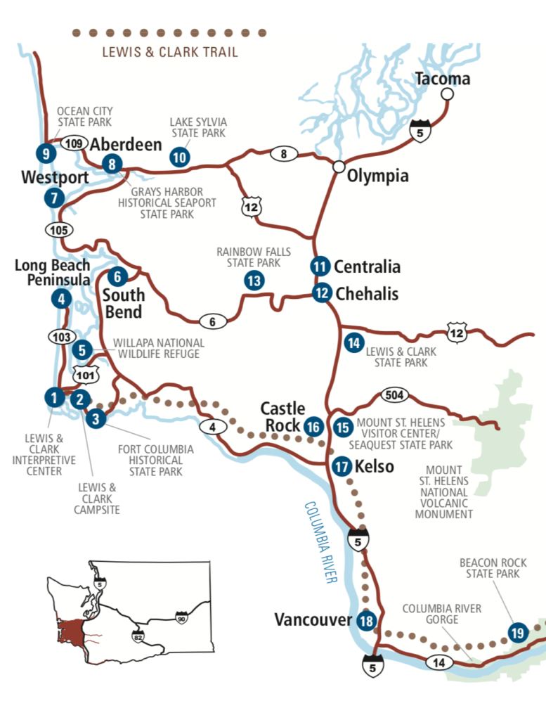
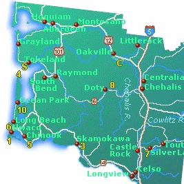
I drove southeast from Grayland Beach to Tokeland and then to Raymond.  The road travels along the edge of the Willapa Bay.  The low tide revealed immense blocks of sand in this very shallow Bay.  Over half the water in the Bay comes in and goes out each day.  

The countryside from Raymond to Pe El or Doty is very beautiful rural country.  I took back roads from Pe El to Vader, and from Vader to Longview along the Cowlitz River.  The main Chelais river goes through Pe El and Chelais while making its way northwest to Aberdeen and Grays Harbor Bay; and, the south Chelais river flows further southeast from Pe El.  The level of "green" is astounding!  

Drove from Raymond to Pe El, then to Vader, then Interstate 5.
Unpack at home. Clean up. Shower. Rest.


It is 53 miles east from Raymond on the Willapa to Chelais via Washington State Road 6.  Always a pleasure.  


Raymond's many metal sculptures.


Chelais


Centralia and Chelais, Southwestern Washington

Centralia  Population 18,183  Images
On Interstate 5 between Portland and Olympia    WA6 Junction   Timber industry, farming, city, businesses, tourism. 
Centralia is 84 miles south of Seattle.  
Centralia Outlets Shopping     Business Directory

Centralia: Weyerhaeuser Timber Company   The company owns most of the Willapa Hills forests to the west of Centralia.  

Chehalis  Population  7,259   Images   Chehalis is 88 miles north of Portland, and 28 miles south of Olympia. 
On Interstate 5 between Portland and Olympia.  About 12 miles north of the I5/WA12 Junction near Mary's Corner. 
Timber industry, farming, city, businesses, tourism. 

Grand Mond   Great Wolf Lodge and Waterpark

Lucky Eagle Rochester Indian Hotel and Casino 

Chehalis River    Images   Newaukum River

Chehalis Reservation Confederated Tribes

Native Indians of Southwestern Washington

Raymond

Raymond  Population 2,975  Pacific County  WB  Junction of US101, WA 6, and WA 105. 
The largest town on the east side of Willapa Bay and largest city in Pacific County. 
Raymond is 35 miles north of Naselle, 56 miles west of Centralia, and 25 miles south of Aberdeen. 

Raymond Images  WB  

Raymond:  Carriage Museum   Willapa Seaport Museum    Harbor/Docks    Sightseeing    Paddling    

Raymond:  Willapa River  Images   WB  There is a north and south fork of the Willapa River in Raymond.  

Raymond:  Steamboats of Willapa Bay   There is a huge Weyerhaeuser lumber mill in Raymond. 
Many fish canneries are in or near South Bend and Raymond.  There are numerous commercial and public docks in the area. 

Raymond Timberland Library

Raymond:  Willapa Paddle Adventures   Paddling canoes or kayaks on the many Willapa Bay rivers is very popular. 

Raymond:  Willapa Hills State Park Trail   56 miles east to Centralia.  River biking trail from Raymond to South Bend. 

Numerous rusted metal sculptures along the roadway in Raymond.  


Four Days in Grayland
By Michael P. Garofalo


Wednesday, June 29, 2022

Morton, Washington

Karen and I spent the night at the Seasons Motel in Morton.  It was a clean, quiet, and nice room for $190.00.  We were tired after a busy day on Mayfield Lake on Tuesday.  

We awoke early on Wednesday.  We drove home from Morton.  Beautiful farmland views.  

Karen and I enjoyed a trip from Vancouver, WA, to Lake Mayfield, WA.  It is about a 100 mile drive one way: north on Interstate 5 and east on Highway 12.  The drive from Mary's Corner to Morton, Randall, or Packwood is easy on Highway 12 which goes over White Mountain Pass and then to Yakima.  

Mick and April were camping (Sunday-Wednesday) at Ike Kinswa State Park near Mossyrock.  We joined them in the morning on Tuesday.  We both went on boat rides with Mick as the boatman driver.  We crossed Mayfield Lake from the dock near the bridge at the State Park.  Then we went up the Cowlitz River to below Mossyrock Dam.  A wonderful sightseeing excursion.  The weather was very overcast and threatening rain.  We had a great dinner of dipped pork and spinach sandwiches.  


Sunday, April 10, 2022

Dipping for Smelt along the Cowlitz River

"Washington State Department of Fish and Wildlife says the 2022 smelt run is expected to be larger than the year before. Dipnetters caught about 90,750 pounds in the five-hour fishery window in 2021, the state reports.

Columbia River smelt are listed as threatened under the Endangered Species Act due to declines in run size in the last decade, which is why recreational fishing is limited to years in which the run size is exceptionally large. Smelt have a range from Long Beach, California, to Chignik Lagoon, Alaska, but the Columbia River has a specific kind of smelt, also called hooligan or eulachon."
-  Vancouver Columbia Newspaper, 4/8/2022

Eulachon smelt runs in the late winter were very important to the many Native Americans living along the lower Columbia River for over 2,000 years until 1800.  These small fish were prized for their high oily fat content and ease of catching.  Sadly, after 1800, nearly 90% of the Native Americans along the lower Columbia River (e.g. Chinook, Clapsop, Cowlitz) died of newly introduced communicable diseases.  


Today, I plan to do some sightseeing along the Cowlitz River from Longview to Castle Rock.


Thursday, January 20, 2022

Astoria, Oregon

Today, I left my cozy yurt and said goodbye to Manzanita.  I drove home to Vancouver.  

I visited Fort Clatsop near Warrenton for the very first time.  This is one part of the Lewis and Clark National Park and National Wildlife Refuge.  Fort Clatsop is a recreation of the camp of the Lewis and Clark expedition crew in the Winter of 1805.  Video: Winter Story.  There is a very nice visitor center with excellent exhibits and a nice gift shop.  I walked around the small log cabins inside the small fort.  It was raining when I toured the recreated fort camp.  

The highway from Astoria to Ranier, Oregon 30, is very good.  It follows along the Columbia River in many places and then inland over hills and valleys.  I take the bridge from Ranier to Longview, then down Interstate 5 to Vancouver.  


Astoria, Oregon - Information

Astoria   Population 9,500   A small town with many tourist attractions.  There are many motels, restaurants, cafes, grocery, museums, theaters, historical sights, marina, docks, hospital, gas, stores, services, supplies. 

Astoria Images  

"Astoria is a port city and the seat of Clatsop County, Oregon, United States. Founded in 1811, Astoria is the oldest city in the state of Oregon and was the first American settlement west of the Rocky Mountains.[7] The county is the northwest corner of Oregon, and Astoria is located on the south shore of the Columbia River, where the river flows into the Pacific Ocean. The city is named for John Jacob Astor, an investor and entrepreneur from New York City, whose American Fur Company founded Fort Astoria at the site and established a monopoly in the fur trade in the early nineteenth century. Astoria was incorporated by the Oregon Legislative Assembly on October 20, 1876.  he city is served by the deepwater Port of Astoria. Transportation includes the Astoria Regional AirportU.S. Route 30 and U.S. Route 101 are the main highways, and the 4.1-mile (6.6 km) Astoria–Megler Bridge connects to neighboring Washington across the river."

Columbia River Maritime Museum

Museums in Astoria

Astoria Lodging

Fort Astoria (1811-1825) History

Astoria Food 

Astoria   History1    History2

Astoria Column Historical Tower

Charter Boat Services in Astoria 

Lower Columbia River: Astoria to Portland, Ilwaco to Vancouver

Long Beach Peninsula  

Lewis and Clark Historic Sites

Clatsop County, Oregon  Population 38,000 

Fort Clatsop  Camp of Lewis and Clark in the Winter of 1805.  Video: Winter Story

Fort Steven's State Park  A World War II military base defending the Columbia River. 

Clatsop People


The following photographs were obtained on the Internet:


Astoria Column


Astoria and Bridge at the Columbia River 

Astoria Downtown


Longview and Ranier


Columbia River Near Clatskanie


Columbia River Near Clatskanie


Thursday, December 16, 2021

Return to Wapato Valley

 I was up at 4 am today.  No rain last night and no gusty winds.  Enjoyed daybreak coffee and cannabis on the cold Yurt porch.  I figure the entire campground is 95% empty.  My Circle B was empty but for me.  I took a short walk to the beach.

Loaded up my Ford Escape and began the drive back to Vancouver.  You must leave by 11 am.  I drove home by US101 and WA4.  

Lewis and Clark called the Columbia River bottom and lowland area between Vancouver and Longview the Wapato Valley because of the many wapato roots and camas bulbs harvested by the native Chinook people in the area.  


With 14.5 hours of darkness each day, I had plenty of time to read.  In the last three days I read the following books:

Chinookan Peoples of the Lower Columbia.  Edited by Robert T. Boyd, Kenneth M. Amers, and Tony A. Johnson.  University of Washington, 2015, 464 pages.  VSCL.  Maps, index, art, bibliography.  Outstanding collection of articles.

Cathlapotle and its Inhabitants 1792-1860.  By Robert Boyd.  U.S. Fish and Wildlife Service, Portland, Oregon, 2011.  Index, 209 pages, many maps and charts, place name index, detailed bibliography, art work.  Fascinating study of native people living the area from For Vancouver to Ilwaco, on both sides of the lower Columbia River, as reported by persons living then.  FVRL. 

The Chinook Jargon and How to Use It: A Complete and Exhaustive Lexicon of the Trade Language.  By George Coombs Shaw in 1909, Ranier Printing, Seattle.  Franklin Classics, 2018, 65 pages.  VSCL. 

Mountain Home: The Wilderness Poetry of Ancient China.  Translated by David Hinton.  New Directions, 2005, 320 pages.  VSCL.